El Nino, La Nina and changing Weather patterns
About El Nino and La Nina
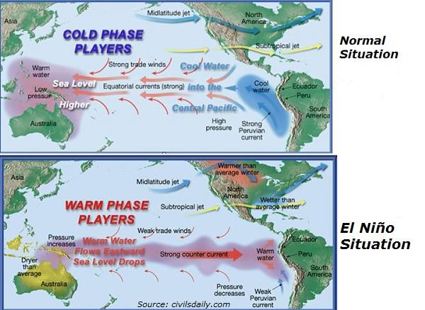
- During normal conditions in the Pacific ocean, trade winds blow west along the equator, taking warm water from South America towards Asia.
- To replace that warm water, cold water rises from the depths — a process called upwelling.
- El Nino and La Nina are two opposing climate patterns that break these normal conditions. They are complex weather patterns resulting from variations in ocean temperatures in the Equatorial Pacific.
- El Niño and La Niña are opposite phases of what is known as the El Niño-Southern Oscillation (ENSO) cycle.
ENSO cycle
- The ENSO cycle is a scientific term that describes the fluctuations in temperature between the ocean and atmosphere in the east-central Equatorial Pacific.
- La Niña is sometimes referred to as the cold phase of ENSO and El Niño as the warm phase of ENSO. These deviations from normal surface temperatures can have large-scale impacts not only on ocean processes, but also on global weather and climate.
El Nino
- El Nino is a climate pattern that describes the unusual warming of surface waters in the eastern tropical Pacific Ocean.
- During El Niño, the surface winds across the entire tropical Pacific are weaker than usual. Ocean temperatures in the central and eastern tropical Pacific Ocean are warmer than average, and rainfall is below average over Indonesia and above average over the central or eastern Pacific.
- Rising air motion (which is linked to storms and rainfall) increases over the central or eastern Pacific, and surface pressure there tends to be lower than average. Meanwhile, an increase in sinking air motion over Indonesia leads to higher surface pressure and dryness.
- Since the Pacific covers almost one-third of the earth, changes in its temperature and subsequent alteration of wind patterns disrupt global weather patterns.
- El Niño causes dry, warm winters in Northern U.S. and Canada and increased flooding risk on the U.S. gulf coast and southeastern U.S. It also brings drought to Indonesia and Australia.

La Nina
- La Nina is the “cool phase” of ENSO, a pattern that describes the unusual cooling of the tropical eastern Pacific.
- The surface winds across the entire tropical Pacific are stronger than usual, and most of the tropical Pacific Ocean is cooler than average. Rainfall increases over Indonesia (where waters remain warm) and decreases over the central tropical Pacific (which is cool). Over Indonesia, there is more rising air motion and lower surface pressure. There is more sinking air motion over the cooler waters of the central and eastern Pacific.
- La Nina has also been associated with heavy floods in Australia. Two successive La Niña events in the last two years caused intense flooding in Australia, resulting in significant damage.
Duration and frequency
- Episodes of El Nino and La Nina typically last nine to 12 months, but can sometimes last for years.
- While their frequency can be quite irregular, El Nino and La Nina events occur every two to seven years, on average.
- Generally, El Nino occurs more frequently than La Nina.
Why in news?
- A new study projects that climate change will significantly impact El Niño-La Niña weather patterns approximately by 2030 — a decade before what was earlier predicted, and around four decades earlier than the suggested timeline without separating the two regimes. This is predicted to result in further global climate disruptions.
- The study used mathematical models that analyzed sea surface temperature (SST) from 1870 to 2019 to observe ENSO and make predictions.
- The study used results from 68 climate models participating in phases five and six of the Coupled Model Intercomparison Project (CMIP) — a coordinated global scientific research project, which compares climate models to real-world observations and intercompares simulations of the earth’s future climate.
Key Findings
- According to the study, published in NatureCommunications journal, increased SST variability from ENSO in the eastern Equatorial Pacific (EP) will emerge around 2030 ( error margin of +/- 6 years), more than a decade earlier than that of the central Pacific
(CP)ENSO.
- Changes in the equatorial Pacific will be visible first due to a stronger increase in EP-ENSO rainfall response, leading to increased SST variability.
- The study noted a significant increase in the amplitude of both EP-ENSO AND CP-ENSO under greenhouse warming, substantiated by strong inter-model agreement.
Impact on Indian Monsoon
- In India, El Niño causes weak rainfall and more heat, while La Niña intensifies rainfall across South Asia , particularly in India’s northwest and Bangladesh during the monsoon.
- At present, India too is witnessing an extended triple dip La Niña which is why India saw surplus rain in September, a month that usually sees the monsoon retreat, for the third year in a row.
- While an IMD forecast indicated that Central India and the southern peninsula would get 6% more than their historical average this year, rainfall far exceeded this and is likely linked to a La Niña.
reference:
Tag:Geography
Subscribe
Login
0 Comments
