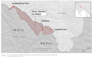
India and Nepal Border dispute

About Kalapani
- The Kalapani territory is an area disputed between India and Nepal, but under Indian administration as part of Pithoragarh district in the Uttarakhand state.
- It shares a border on the north with the Tibet Autonomous Region of China and Nepal in the east and south.
- The valley of Kalapani, with the Lipulekh Pass at the top, forms the Indian route to Kailash–Mansarovar, , a revered Hindu pilgrimage site in the Tibetan plateau.
- It is also the traditional trading route to Tibet for the Bhotiyas of Uttarakhand.
Treaty of Sugauli
- The Treaty of Sugauli signed by Nepal and British East India Company in 1816 defines the Kali River as Nepal’s western boundary with India.
- According to the treaty, Nepal lost the regions of Kumaon-Garhwal in the west and Sikkim in the east.
- However, what is meant by “Kali River” in the upper reaches is unclear because many mountain streams come to join and form the river.
- From 1879 onwards, the survey maps show the stream that flows down from the Lipulekh Pass as the Kali River.
- This stream has served as the border between India and Nepal until India’s independence.
What is the issue?
- However, the discrepancy in locating the source of the river led to boundary disputes between India and Nepal, with each country producing maps supporting their own claims.
- Kalapani has been controlled by India’s Indo-Tibetan Border Police since the Sino-Indian War with China in 1962.
Why in News?
- Recently, Nepal published a revised official map showing the areas of Lipulekh, Kalapani, and Limpiyadhura as part of its territory.
- However, the move drew sharp criticism from India which said the map includes parts of Indian territory.
Subscribe
Login
0 Comments
