Why is the Land in Joshimath sinking?
What’s the news?
- Joshimath, the gateway to famous pilgrimage sites like Badrinath and Hemkund Sahib and international skiing destination Auli, is facing a major challenge due to land subsidence.
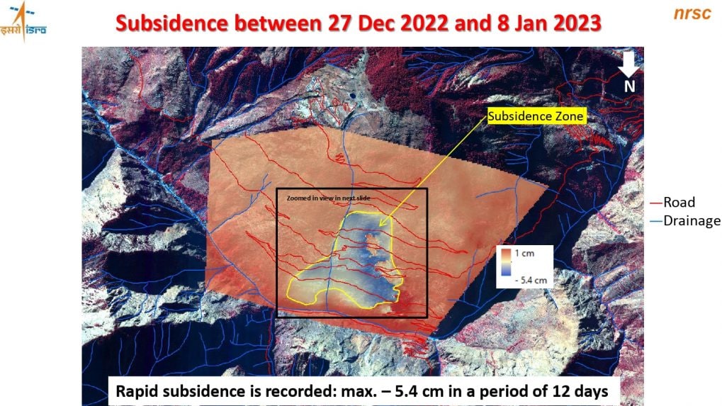
- It has witnessed a rapid sinking of 5.4cm in just 12 days — between 27 December 2022 and 8 January 2023.
- Joshimath is sinking gradually with huge cracks developing in houses, on roads and fields. Many houses have tilted and are sinking.
Where is Joshimath located?
- Joshimath is a small town in the Chamoli district of Uttarakhand, India. It lies in the Garhwal Himalayas, 60 kms on the way to Badrinath.
- The beautiful town is surrounded with coniferous and oak forests, and also offers a fantastic view of mountain peaks of Nanda Devi, Dunagiri, Beethartoli, Neelkanth, Hathi Parbat and Kamet.
- The town is also a gateway to noted sites of pilgrimage – Badrinath for Hindus and Hemkund Sahib for Sikhs; the international skiing site of Auli; and the Valley of Flowers, a UNESCO World Heritage site.
What is Subsidence?
- According to the National Oceanic and Atmospheric Administration (NOAA), Subsidence is the “sinking of the ground because of underground material movement”.
- It can happen for a host of reasons, man-made or natural, such as the removal of water, oil, or natural resources, along with mining activities. Earthquakes, soil erosion, and soil compaction are also some of the well-known causes of subsidence.

Why is Joshimath Sinking?
- The main reason for sinking can be attributed to unplanned construction, overpopulation, obstruction of the natural flow of water, and hydel power activities.
- Geological setting
- Joshimath’s geological setting together with the unplanned and rampant construction in and around the town, have resulted in land subsidence.
- Warning bells for Joshimath were first sounded about 50 years ago in the MC Mishra committee report, which pointed to unplanned development in the area that already had natural vulnerabilities.
- The signs of sinking first appeared in October 2021. The situation became particularly alarming towards the end of 2022 and the beginning of 2023, when large parts of the town experienced sudden land-sinking and several houses developed major cracks.
- Joshimath is built on the deposits of an old landslide, meaning it rests on a deposit of sand and stone, not rock meaning the slopes can be destabilised even by slight triggers.
- The town is also in Zone V, denoting highest risk, in India’s seismic zonation scheme. It lies between two thrusts, the Main Central Thrust (MCT) and the Vaikrita Thrust (VT), and thus occupies a seismically active terrain.
- Joshimath is also prone to extreme weather. “Climatologically, Joshimath lies in a region that frequently receives high-intensity, focussed rainfall.
- Eg: A report on Joshimath published by the Uttarakhand State Disaster Management Authority (USDMA) in September 2022 said that floods in June 2013 and February 2021 heightened erosion in the area. Very heavy rains in October 2021 – 190 mm in 24 hours – also worsened the subsidence and vulnerability to landslides.
- The reports have pointed out that subsidence in Joshimath might have been triggered by the reactivation of a geographic fault — defined as a fracture or zone of fractures between two blocks of rock — where the Indian Plate has pushed under the Eurasian Plate along the Himalayas.
- Hydel Power activities
- Locals have blamed the NTPC’s 520-MW Tapovan Vishnugad hydropower project, under construction in the area, for exacerbating the Joshimath land subsidence.
- Road Projects
- The 6-km Helang-Marwari bypass, being built by the Border Roads Organisation (BRO), is also under scrutiny for weakening slopes and further destabilising the local topography. The bypass is part of the 825-km Char Dham highway expansion project in Uttarakhand, which experts have already questioned for unscientific slope-cutting, which resulted in several landslides.
- Inadequate Drainage and Wastewater Disposal
- The 2022 USDMA report also pointed to a lack of drainage and wastewater disposal systems as being part of the subsidence problem as the accumulated water seeps into the rocks below, softening them.
- About 85% of buildings in the town – including those owned by the army – aren’t connected to a sewerage system and have soak pits instead.
- The 1976 Mishra committee report had warned that these pits could create “cavities between soil and boulders”, as well as that inadequate drainage could lead to landslides.
https://www.uttarakhand-tourism.com/uttarakhand/joshimath.php
Subscribe
Login
0 Comments
