Swell Waves
Why in News?
- The Indian National Centre for Ocean Information Services (INCOIS) forecasted that high sea waves, also known as swell waves, might hit the coastal areas of Goa, Maharashtra, West Bengal, Odisha, Tamil Nadu, Kerala, Lakshadweep, Karnataka, Gujarat, and Andaman & Nicobar Islands.
What are Swell Waves?
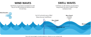
- The waves that are formed, not due to the local winds, but rather due to distant storms like hurricanes, or even long periods of fierce gale winds are called Swell waves.
- A gale is a strong, sustained wind with wind speeds between 62 km/h to 74 km/h
- During such storms, huge energy transfer takes place from the air into the water, leading to the formation of very high waves.
- Such waves can travel thousands of kilometres from the storm centre until they strike shore.

What is the difference between swell waves and tsunamis?
- Unlike swell waves, a tsunami is a series of enormous waves created by an underwater disturbance usually associated with earthquakes occurring below or near the ocean.
- Tsunamis are around 10 times faster than swell waves.
- Although both swell waves and tsunamis slow down near the coast, the swell waves hit land at 30–50 km/h.
About INCOIS (Indian National Centre for Ocean Information Services)
- INCOIS was established as an autonomous body in 1999 under the Ministry of Earth Sciences (MoES) and is a unit of the Earth System Science Organisation (ESSO).
- Earth System Science Organisation (ESSO) was set up in October 2007 as an executive arm to implement policies and programmes of the Ministry of Earth sciences.
- It deals with four branches of earth sciences, viz. (i) Ocean Science & Technology (ii) Atmospheric and Climate Science (iii) Geoscience and (iv) Polar Science and Cryosphere.
Functions and Responsibilities of INCOIS
- Provides round-the-clock monitoring and warning services for the coastal population on tsunamis, storm surges, high waves, etc.
- Provides daily advisories to fisher folk to help them easily locate areas of abundant fish in the ocean while saving on both fuel and time used to search for the same.
- Short term (3-7 days) Ocean State Forecasts (waves, currents, sea surface temperature, etc.) are issued daily to fisher folk, the shipping industry, the oil and natural gas industry, the Navy, the Coast Guard, etc. These forecasts inform users about the expected sea conditions during the next few days and help them to plan their activities at sea.
- Training and capacity building for students, young researchers in India and Indian Ocean Rim Countries through short and long duration training courses.
Subscribe
Login
0 Comments
