India-China Border issues

Background
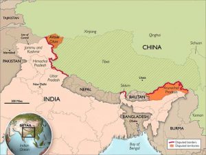
- The disputed boundary between India and China, also known as the Line of Actual Control (LAC), is divided into three sectors: viz. Western (Ladakh, Kashmir), middle (Uttarakhand, Himachal) and eastern (Sikkim, Arunachal).
- The countries disagree on the exact location of the LAC in various areas, so much so that India claims that the LAC is 3,488 km long while the Chinese believe it to be around 2,000 km long.
Johnson Line
- The boundary dispute in the Western Sector pertains to the Johnson Line proposed by the British in the 1860s which put Aksai Chin in the then princely state of Jammu and Kashmir.
- Independent India used the Johnson Line and claimed Aksai Chin as its own. However, China stated that it had never acceded to the Johnson Line and refused to cede Aksai Chin to India.
Middle Sector
- In the Middle Sector, the dispute is a minor one. It is the only one where India and China have exchanged maps on which they broadly agree.
McMahon Line
- The disputed boundary in the Eastern Sector of the India-China border is over the McMahon Line.
- Representatives of China, India and Tibet in 1913-14 met in Shimla, where an agreement was proposed to settle the boundary between Tibet and India, and Tibet and China.
- Though the Chinese representatives at the meeting initialled the agreement, they subsequently refused to accept it claiming that Tibet is not a sovereign nation and thus the McMahon Line has no legal standing.
- At the heart of boundary dispute is the issue of Arunachal Pradesh, which China describes as ‘Southern Tibet’.
How is the LAC different from the Line of Control with Pakistan?
|
Mechanism to prevent border flare-ups
- The two countries engaged in Confidence Building Measures (CBMs) on the border with bilateral agreements signed in 1993, 1996, 2005, 2012 and 2013.
- During Prime Minister Atal Bihari Vajpayee’s visit to China in 2003, the two sides agreed on the appointment of special representatives for consultations aimed at arriving at a framework for a boundary settlement that would provide the basis for the delineation and demarcation of the border.
- In October 2013, the two sides signed the Boundary Defence Cooperation Agreement to prevent any flare up along the un-demarcated border. This encompasses both military level and diplomat level dialogue mechanism.
Why in News?
- Indian and Chinese armies rushed in additional troops in areas around Pangong Tso lake in eastern Ladakh, after recent clashes between the soldiers of both sides.
- The LAC mostly passes on the land, but Pangong Tso is a unique case where it passes through the water as well. The points in the water at which the Indian claim ends and Chinese claim begins are not agreed upon mutually.
- Most of the clashes between the two armies occur in the disputed portion of the lake.
Reasons for chinese move:
- Increasing infrastructure competition along LAC
The spark for the current stand-off with China, with the ongoing face-off situations in the Galwan River valley, Pangong Lake and other areas, is the increasing infrastructure competition along the LAC
- Increasing chinese assertiveness
China appears to be asserting itself along the LAC in the Western sector which is more similar to the 2013 and 2014 border stand-offs between China and India.
- Strategic considerations
China could be responding to the deterioration of China-India ties amid the coronavirus pandemic.
Way forward:
- The lack of a formal agreement regarding the location of the LAC will ensure that future incidents and crises are bound to recur. Thus, reaching such a formal agreement even if the underlying territorial dispute cannot be resolved is more necessary than ever before.
Pangong Tso
|
References:
https://indianexpress.com/article/explained/china-india-line-of-actual-control-ladakh-6427647/
