Satellites for Indian Agriculture-Bharat Krishi Satellite Programme
Why in News:
- The Indian Space Research Organisation (ISRO) has proposed dedicated satellites for supporting the country’s agriculture sector.
- Discussions have been held with the Department of Agriculture, the Government of India, on the proposed ‘Bharat Krishi Satellite’ programme
How will it work?
- A minimum of two satellites will be needed to guarantee adequate coverage of the entire agricultural area of the country.
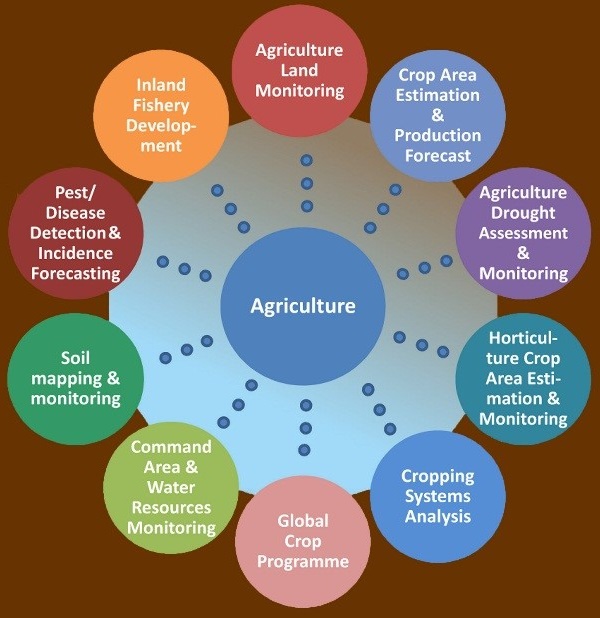
- They will aid a gamut of farm-related activities related to crop forecasting, pesticide application, irrigation, soil data, and generation of critical data related to drought.
- Nitrogen fertilizer is one of the major limitations for wheat production in some parts of India- We can use remote sensing to better understand yield gaps, which are the difference between actual yields a farmer gets and possible yields based on local growing conditions.
- Using satellite imagery we can track how mechanical fertilizer spreaders could close yield gaps in low-yielding farms. Mechanical fertilizer spreaders help farmers distribute fertilizers across a field more evenly than hand-broadcasting. These low-cost tools could improve farmer income and nitrogen use efficiency.
- The high-resolution imagery enables to develop a reliable model of crop yields across a wider area.
- Receive data on vegetation water stress, evapotranspiration and soil organic carbon data on top of the weather forecast data from the nearest weather station.

The need
- Croplands cover over half of India’s land area, and the agricultural sector employs about 590 million people in the country.
- Researchers can’t rely on census data alone to monitor agriculture in India because many farms are small (less than 2 hectares), whereas censuses typically report statistics at the state or national level and mask important heterogeneity.
- Remote sensing provides an essential vantage point for monitoring agriculture in India and investigating ways to sustainably improve crop yields.
Issues faced
- Current deficiencies include a discontinuity in earth observation missions, low utilisation of available remote sensing data, technology gaps and absence of a streamlined mechanism for data processing and dissemination as required by the industry
Way forward
- An ‘Earth Observation Council’ be created for addressing the current deficiencies in earth observation capabilities and data utilisation. Such a council can tackle shortcomings in this area in a centralised manner
- Making farmers the end-users of SAAS and allied agritech products.
- A shift of end-users from state administration to digitally-literate farmers has to be made.
Additional Information
Satellites designed by ISRO- The satellites designed by ISRO, which are currently in operation, to support these services and applications, include Resourcesat-2, Resourcesat-2A, RISAT-1, Cartosat-1, Kalpana-1, INSAT-3D and INSAT-3DR.
| SN | Satellite | Objectives |
| 1 | Resourcesat | To provide multispectral images for inventory and management of natural resources, Crop production forecast, wasteland inventory, Land & Water Resources development, and Disaster Management Support. |
| 2 | Cartosat-1 | To provide high resolution images for Cartographic mapping, Stereo data for Topographic Mapping & DEM, and host of DEM Applications – Contour, Drainage network, etc. |
| 3 | RISAT-1 | To provide all weather imaging capability useful for agriculture, particularly paddy and jute monitoring in kharif season and management of natural disasters. |
| 4 | Kalpana-1 | To provide meteorological data to enable weather forecasting services. |
| 5 | INSAT-3D | Designed for enhanced meteorological observations, including vertical profile of the atmosphere in terms of temperature and humidity for improved weather forecasting and disaster warning. |
How does the Ministry of Agriculture use satellites
The Ministry of Agriculture and Farmer’s Welfare is another key end-user of ISRO’s satellite data for its projects such as
- Crop Forecasting– Forecasting Agricultural output using Space, Agro-meteorology and Land-based observations (FASAL)
- Drought Assessment- National Agricultural Drought Assessment and Monitoring Systems (NADAMS)
- Horticulture assessment and development- Coordinated programme on Horticulture Assessment and Management using Geoinformatics (CHAMAN)
- Crop insurance- Crop Insurance using Space technology and Geoinformatics (KISAN) now incorporated into Pradhan Mantri Fasal Bima Yojna
References:
- https://www.thehindu.com/news/national/kerala/isro-proposes-dedicated-satellites-for-the-agricultural-sector/article66005541.ece
- https://www.earthdata.nasa.gov/learn/articles/satellites-help-improve-crop-yields-india
- https://pib.gov.in/newsite/printrelease.aspx?relid=155408
Subscribe
Login
0 Comments
