Galwan Clash
Why in News:
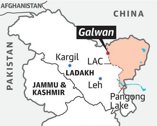
- A year since the violent clash between the Armies of India and China in the Galwan Valley in eastern Ladakh, the Chinese People’s Liberation Army (PLA) has built additional accommodation in the depth areas along the Line of Actual Control (LAC).
Background

- The disputed boundary between India and China, also known as the Line of Actual Control (LAC), is divided into three sectors: viz. Western (Ladakh, Kashmir), middle (Uttarakhand, Himachal) and eastern (Sikkim, Arunachal).
- The countries disagree on the exact location of the LAC in various areas, so much so that India claims that the LAC is 3,488 km long while the Chinese believe it to be around 2,000 km long.
Johnson Line
- The boundary dispute in the Western Sector pertains to the Johnson Line proposed by the British in the 1860s which put Aksai Chin in the then princely state of Jammu and Kashmir.
- Independent India used the Johnson Line and claimed Aksai Chin as its own. However, China stated that it had never acceded to the Johnson Line and refused to cede Aksai Chin to India.
Middle Sector
- In the Middle Sector, the dispute is a minor one. It is the only one where India and China have exchanged maps on which they broadly agree.
McMahon Line
- The disputed boundary in the Eastern Sector of the India-China border is over the McMahon Line.
- Representatives of China, India and Tibet in 1913-14 met in Shimla, where an agreement was proposed to settle the boundary between Tibet and India, and Tibet and China.
- Though the Chinese representatives at the meeting initialled the agreement, they subsequently refused to accept it claiming that Tibet is not a sovereign nation and thus the McMahon Line has no legal standing.
- At the heart of the boundary dispute is the issue of Arunachal Pradesh, which China describes as ‘Southern Tibet’.
How is the LAC different from the Line of Control with Pakistan?
- The LoC emerged from the 1948 ceasefire line negotiated by the UN after the Kashmir War.
- It was designated as the LoC in 1972, following the Shimla Agreement between the two countries.
- It is delineated on a map signed by Director General of Military Operations (DGMOs) of both armies and has the international sanctity of a legal agreement.
- The LAC, in contrast, is only a concept – it is not agreed upon by the two countries, neither delineated on a map or demarcated on the ground.
Is Galwan valley the only area?
- The PLA has also conducted exercises in Tibet and opposite Arunachal Pradesh. For instance, the PLA conducted a small arms training at Shigatse in Tibet. The PLA soldiers were trained in anti-tank rocket launchers, grenade launchers, anti-aircraft machine guns and other weapons.
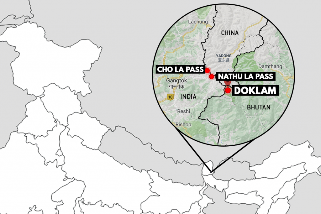
- Recently, troops from India and China were involved in a clash in Naku La in Sikkim.
Why is NakuLa important for China?

- China has been developing two air defence positions that will cover the 2017 Doklam stand-off area and also Naku La in Sikkim.
- It is also close to Siliguri Corridor (Chicken’s Neck Corridor) that connects mainland India with North East India. By taking advantage of this geographically important position, China can get more influence over Arunachal Pradesh, which China claims as its territory.
- This could also be a pressure tactic by China to force India on its objection to the China–Pakistan Economic Corridor (CPEC).
Reasons Behind Increased China’s Deployment
- India’s pro-US stance (e.g. Quad) in the face of US-China tensions.
- India’s assertion about Gilgit-Baltistan is seen by China as an implied attack on China’s flagship project, the China-Pakistan Economic Corridor (CPEC).
- India’s decision to improve its border infrastructure(ex:Darbuk-Shyok-Daulat Beg Oldie road).
- India is a rising force in the Asian continent.
Modus operandi of China
- China’s history of territorial conquests falls in the ‘fait accompli’ category. Sparsely populated/unpopulated and undefended territories have been the prime targets. Chinese moves in East Asia, South China Sea and Sino-Indian border provide ample evidence.
- The current situation in Ladakh and Sikkim seems to suggest that China is playing its favourite game of seizing disputed territory that is not populated and is not permanently occupied by the border guarding forces. The confrontation in Galwan River valley, Pangong Tso, and Naku La in north Sikkim are examples.
- Once incursions are made by China, military assets, including the creation of permanent roads and military structures are created, along with building of township for a civilian population
- China is trying to influence India’s decision-making in the context of the US-China geopolitical competition.
Additional Details
Pangong Tso

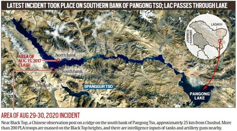
- Pangong Tso is a long narrow, deep, endorheic (landlocked) lake situated at a height of more than 14,000 ft in the Ladakh Himalayas.
- The brackish water lake freezes over in winter.
- By itself, the lake does not have major tactical significance. But it lies in the path of the Chushul approach, one of the main approaches that China can use for an offensive into Indian-held territory.
- Indian assessments show that a major Chinese offensive, if it comes, will flow across both the north and south of the lake. During the 1962 war, this was where China launched its main offensive

[…] https://officerspulse.com/galwan-clash/ […]